


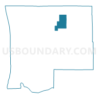
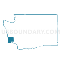
Willapa Voting District, Pacific County, Washington
About
Outline

Summary
| Unique Area Identifier | 687864 |
| Name | Willapa Voting District |
| County | Pacific County |
| State | Washington |
| Area (square miles) | 22.98 |
| Land Area (square miles) | 22.83 |
| Water Area (square miles) | 0.15 |
| % of Land Area | 99.36 |
| % of Water Area | 0.64 |
| Latitude of the Internal Point | 46.68879830 |
| Longtitude of the Internal Point | -123.63767260 |
Maps

Graphs
Select a template below for downloading or customizing gragh for Willapa Voting District, Pacific County, Washington


Neighbors
Neighoring Voting District (by Name) Neighboring Voting District on the Map
- Menlo-Firdale Voting District, Pacific County, WA
- North River Voting District, Pacific County, WA
- Raymond Ward 2 Rural, Pacific County, WA
- Raymond Ward 3 Rural, Pacific County, WA
- Smith Creek Voting District, Pacific County, WA
- South Fork Voting District, Pacific County, WA